Minnesota Urbex Map (USA) – Urban Exploration
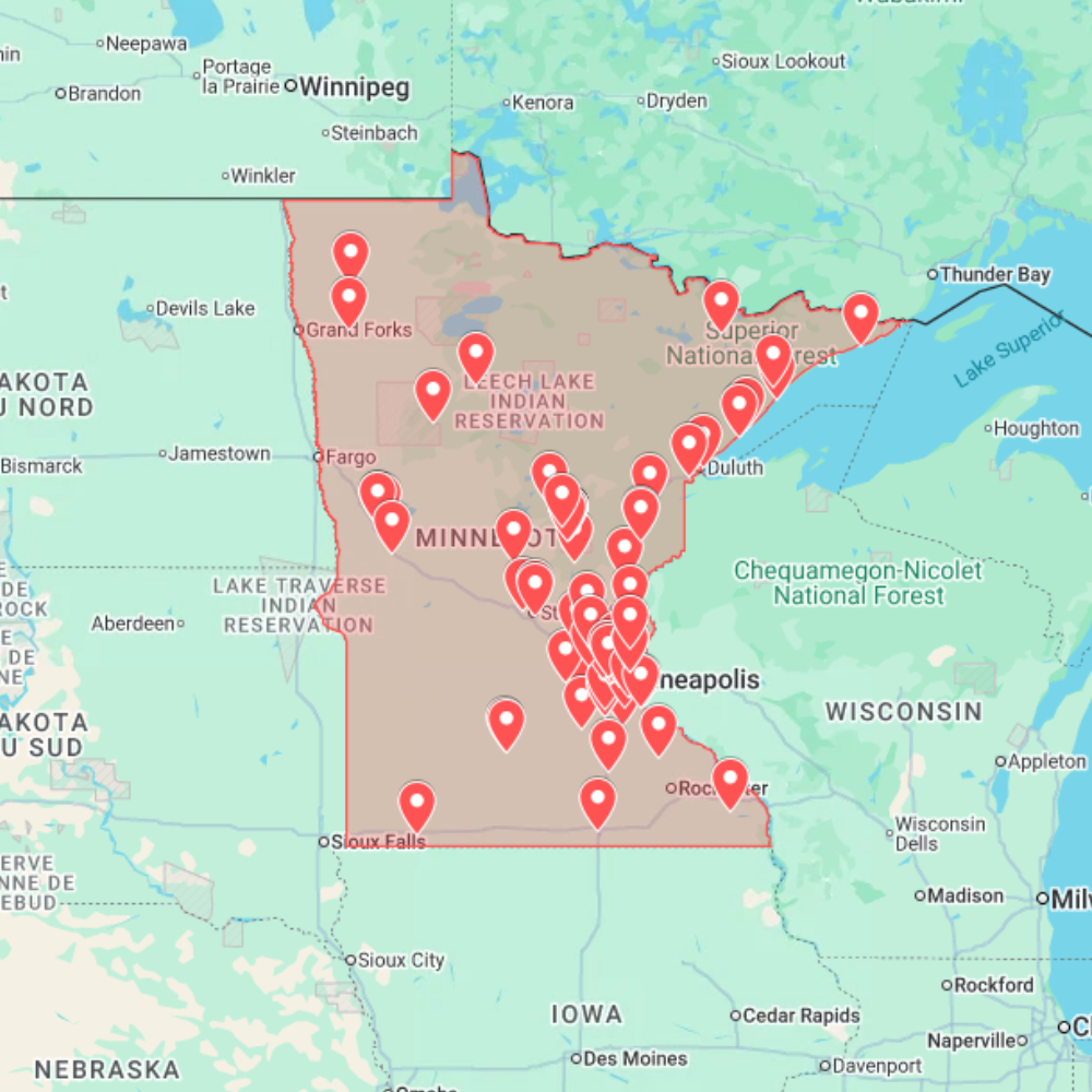
Discover 106 Verified Abandoned Locations Across Minnesota. The Minnesota Urbex Map gives you access to 106 verified abandoned locations carefully selected across one of the Midwest’s most fascinating states. From former industrial complexes and flour mills to abandoned mining sites, hospitals, schools, and forgotten rural communities, this digital GPS database helps you uncover places that have been left behind by time.
Whether you’re an experienced urban explorer, a photographer looking for unique locations, or simply passionate about forgotten architecture, this map allows you to spend less time researching and more time exploring. Every location has been organized into an intuitive KML and KMZ database compatible with Google Maps and Google Earth, making route planning simple and efficient.
Minnesota’s industrial heritage, iron mining history, and vast natural landscapes have created an exceptional variety of abandoned places. From the Mississippi River corridor to the forests of the Iron Range, every region offers unique exploration opportunities waiting to be discovered.
Explore Every Region of Minnesota
Minneapolis & St. Paul Metropolitan Area
The Twin Cities are home to some of Minnesota’s most iconic abandoned industrial sites. Former flour mills, manufacturing plants, warehouses, commercial buildings, schools, and forgotten infrastructure line the Mississippi River, reflecting the region’s rich industrial history and economic development.
Duluth & Lake Superior Shore
Duluth’s mining and maritime heritage has left behind abandoned ore processing facilities, shipping infrastructure, grain elevators, industrial warehouses, and historic commercial buildings overlooking Lake Superior. These locations offer a unique combination of industrial architecture and waterfront exploration.
St. Cloud & Central Minnesota
Central Minnesota is known for its granite industry and agricultural heritage. The region features abandoned quarries, former manufacturing facilities, warehouses, commercial districts, and rural buildings that showcase decades of local economic activity.
Northern Minnesota & The Iron Range
Northern Minnesota offers a completely different exploration experience. Discover abandoned open-pit mines, former mining communities, railway infrastructure, logging camps, isolated farmsteads, and forgotten settlements surrounded by forests and thousands of lakes.
Types of Abandoned Places Included
The Minnesota Urbex Map includes a carefully curated collection of abandoned locations representing the state’s industrial, mining, agricultural, and commercial history.
Among the locations included, you’ll discover:
- 🏭 Industrial factories and manufacturing facilities
- 🌾 Historic flour mills
- ⛏️ Mines, quarries, and mining infrastructure
- 🚢 Port and shipping facilities
- 🏥 Hospitals and healthcare buildings
- 🏫 Schools and educational institutions
- 🏨 Hotels and commercial buildings
- 🚂 Railway infrastructure
- 🚜 Agricultural buildings and farmsteads
- 📍 Hidden landmarks and forgotten places
Every location offers excellent opportunities for urban exploration, photography, architectural documentation, filmmaking, and historical research.
Why Explore Minnesota?
Minnesota may not be the first destination that comes to mind for urban exploration, but it hides an impressive variety of abandoned locations shaped by more than a century of industry, mining, agriculture, and transportation.
The state’s flour mills helped make Minneapolis one of the world’s leading milling cities, while the Iron Range supplied iron ore that fueled American industry for generations. Around Lake Superior, abandoned shipping infrastructure and industrial facilities tell the story of Minnesota’s maritime economy, while countless rural communities preserve forgotten buildings scattered across forests, farmland, and remote landscapes.
This diversity makes Minnesota one of the Midwest’s most rewarding destinations for explorers looking to discover authentic abandoned places away from heavily publicized locations.
Why Choose This Minnesota Urbex Map?
Instead of spending hours browsing outdated forums, satellite imagery, and scattered websites, access a professionally organized GPS database built specifically for urban explorers.
Included Benefits
✔ 106 Verified Abandoned Location
✔ Compatible with Google Maps & Google Earth
✔ Instant Digital Download
✔ KML & KMZ File Formats
✔ Mobile & Desktop Compatible
✔ Regularly Updated Database
✔ Save Hours of Manual Research
✔ Easy Route Planning
Compatible With Google Maps & Google Earth
After your purchase, you’ll instantly receive downloadable KML and KMZ files compatible with Google Maps, Google Earth, and most GPS applications.
Simply import the file to display every location on an interactive map, create personalized exploration routes, organize road trips, and navigate directly from your smartphone, tablet, or computer.
Whether you’re exploring a single location or planning a multi-day adventure across Minnesota, the map provides an efficient way to organize every trip.
Technical Specifications
Locations: 106 Verified Abandoned Places
Format: KML & KMZ
Compatibility: Google Maps & Google Earth
Devices: Windows, macOS, Android, iPhone & iPad
Delivery: Instant Digital Download
Updates: Regular Database Improvements
Access: Immediate After Purchase
How to Install
- Purchase and download your KML or KMZ file.
- Open Google Earth or Google My Maps.
- Import the downloaded file.
- Browse all mapped locations and start planning your next exploration.
Installation takes less than two minutes and works on desktop, tablet, and mobile devices.
Frequently Asked Questions
How many locations are included?
The Minnesota Urbex Map contains 106 verified abandoned locations distributed across the entire state.
What types of locations are included?
The database features abandoned factories, flour mills, hospitals, schools, mines, quarries, railway infrastructure, ports, agricultural buildings, warehouses, and many other forgotten places.
Can I use the map with Google Maps?
Yes. Every purchase includes KML and KMZ files fully compatible with Google Maps, Google Earth, and most GPS applications.
Can I access the map on my smartphone?
Absolutely. The files work on Android, iPhone, tablets, and desktop computers.
Are new locations added?
Yes. Our database is regularly reviewed and expanded as new abandoned locations are discovered and verified.
Start Exploring Minnesota’s Forgotten Places Today
Behind Minnesota’s modern cities and picturesque lakes lies a hidden world of abandoned flour mills, iron mines, industrial complexes, hospitals, schools, railway infrastructure, and forgotten rural communities waiting to be explored.
Download your Minnesota Urbex Map today and gain instant access to 106 verified abandoned locations, allowing you to discover more places, save valuable research time, and plan your next urban exploration adventure with reliable GPS coordinates compatible with Google Maps and Google Earth.