

A France urbex map can help you organize abandoned places research, compare regions and prepare a safer route. It should not be used to expose fragile locations or to assume that entry is allowed. France has industrial ruins, former public buildings, rural sites and redevelopment zones, but ownership, access and safety can change quickly.
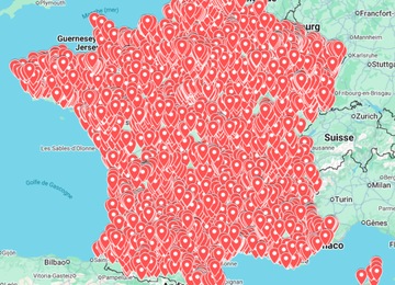
This guide shows how to use maps responsibly for France without publishing exact coordinates. If you need a practical starting point, open the France Urbex Map, compare other regions by country, or browse the shop for more abandoned places maps.
Why France is a strong urbex map destination
France works well for structured urbex research because the country combines dense urban areas, old industrial corridors, rural villages, rail history and coastal infrastructure. A map helps you avoid random searching and focus on a route that can be checked carefully before you travel.
- Industrial corridors: old factories, warehouses, mills and transport-linked buildings.
- Rural research: barns, closed schools, farm buildings and local heritage leads.
- Coastal and military history: visible remains, bunkers and historic structures that may be accessible only from legal public viewpoints.
- City edges: redevelopment zones where a site can change status quickly.
- Photography routes: exterior viewpoints, textures, facades and safe public approaches.
A safe workflow for using a France urbex map
Responsible route checklist
- Choose one region first. Keep the route compact: a department, city belt or industrial valley is easier to verify than a long national list.
- Build a private shortlist. Save possible places in a private map, KML layer or route planner without reposting coordinates publicly.
- Check current status. Look for recent photos, redevelopment news, active businesses, fences, warning signs and local restrictions.
- Remove unsafe stops. Skip sealed buildings, active sites, unstable interiors, contaminated industrial land and any place requiring forced entry.
- Plan legal alternatives. Add public viewpoints, heritage sites, legal photo walks or museums nearby in case a stop is restricted.
- Travel prepared. Save offline maps, daylight windows, weather, fuel, emergency contacts and a clear return route.
How to research without revealing sensitive coordinates
Good urbex research protects places as much as it helps explorers. Publicly sharing exact addresses can increase vandalism, theft, unsafe visits and unwanted attention from people who have not checked the risks. A safer approach is to discuss regions, building types and planning methods while keeping fragile coordinates private.
| Research step | Useful tool | What to avoid |
|---|---|---|
| Regional scouting | Curated map, Google Maps, local history pages | Publishing exact pins in social captions |
| Visual verification | Google Earth, Street View where available, recent public photos | Trusting old images without checking current use |
| Route building | Private saved list or KML layer | Long routes with no backup plan |
| Safety screen | Weather, daylight, access notes, local rules | Forcing entry or ignoring signs/fences |
| Publishing content | General region, exterior photos, safety notes | Exact addresses for fragile or private sites |
Google Maps vs Google Earth for France urbex planning
Google Maps is useful for travel time, nearby services, saved places and road navigation. Google Earth is often better for pre-checking terrain, roof condition, vegetation, access roads and historical imagery. If you work with KML files, separate your layers by region, trip date or location type so the route stays readable.
For a deeper setup, read the Google Earth KML urbex map guide. If your searches are broader, the abandoned places near me guide explains how to filter local results without rushing into unsafe locations.
When a paid France urbex map is useful
A paid map is useful when it saves research time and gives you a structured starting point. It can help you compare clusters, build a weekend route and avoid wasting hours on vague searches. It should still be treated as a research aid, not as permission to enter a property or proof that a site is still abandoned today.
- Use it to identify regions and possible clusters, not to visit every pin blindly.
- Verify each candidate with recent public signals before leaving.
- Respect signs, fences, neighbours, active use and private ownership.
- Choose exterior photography or legal viewpoints when access is uncertain.
- Keep fragile places out of public coordinate dumps and comment threads.
Start with the France Urbex Map if France is your next target. If you are comparing countries, the recent Canada urbex map guide shows how route planning changes when distances are larger.
Safety and legal reminders
Urban exploration can involve structural collapse, broken glass, asbestos, mould, unstable floors, poor air quality, security patrols and legal risks. A map can reduce research friction, but it never replaces permission, caution and common sense.
- Do not break locks, force doors, climb barriers or damage property.
- Avoid active industrial land, sealed buildings, live rail areas and unstable interiors.
- Do not explore alone when a place is remote or structurally uncertain.
- Carry light, water, sturdy footwear, a charged phone and basic first aid.
- Leave immediately if a site appears active, restricted or unsafe.
FAQ: France urbex maps
Can I use Google Maps to find abandoned places in France?
Yes, but use it as one layer only. Combine saved places with Google Earth, recent public photos, local history research and current access checks before planning any trip.
Does a France urbex map mean the places are legal to enter?
No. A map cannot guarantee legal access. Ownership, signage, security, redevelopment and structural condition can change at any time.
Should I share exact coordinates online?
It is usually better not to share exact coordinates for fragile, private or easily damaged locations. Discuss regions and planning methods instead.
What should I check before visiting a place from a map?
Check current status, visible restrictions, weather, daylight, structural risk, ownership clues, nearby activity and safe backup options.