
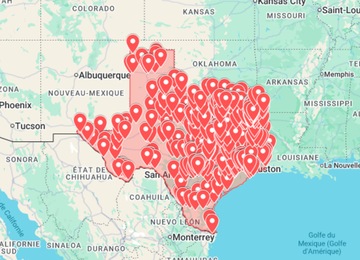
A Texas urbex map can make abandoned places research more organized, especially in a state where distances are large and clusters can be far apart. The goal is not to expose sensitive coordinates or assume that every place is open. A good map helps you compare regions, prepare safer routes and decide what needs fresh verification before you travel.
This guide explains how to use Texas map research for urban exploration without turning it into a risky address list. If you want a practical starting point, open the Texas Urbex Map, compare the broader United States urbex map, or browse all maps in the shop.
Why Texas needs a different urbex route strategy
Texas is not a compact weekend destination. A route that looks simple on a pin map can become a long drive with limited daylight, weather exposure and few backup options. For SEO searches such as “abandoned places Texas”, “urbex Texas map” or “abandoned places near me”, the useful answer is not a raw coordinate dump: it is a method for narrowing a huge area into realistic, safer research zones.
- Large drive times: check distance, fuel stops and return routes before adding too many locations.
- Different terrain: urban edges, rural towns, industrial corridors and desert-like areas need different preparation.
- Fast status changes: redevelopment, demolition, active use and security can change a location quickly.
- Weather risk: heat, storms and flooding can turn a simple exterior photo stop into a bad plan.
- Legal uncertainty: a map pin is never permission to enter private property.
A practical Texas urbex map workflow
Route planning checklist
- Pick one Texas zone. Start with a city belt, region or road corridor instead of trying to cover the whole state.
- Build a private shortlist. Save candidates in a private Google Maps list or KML layer without reposting exact pins publicly.
- Check current signals. Look for recent public photos, business activity, redevelopment mentions, fences, signs and obvious access changes.
- Remove weak stops. Skip sealed buildings, active sites, dangerous interiors, live rail areas and places that require forced entry.
- Add legal alternatives. Include public viewpoints, historic districts, legal photo walks or open heritage sites nearby.
- Plan the return. Save offline maps, daylight windows, weather, water, fuel and emergency contacts.
How to organize Texas abandoned places research
When you search for abandoned places in Texas, separate research into layers. A curated map is useful for direction, but it should be combined with Google Earth, recent public imagery, local history, road access checks and a safety screen. Keep exact coordinates private for fragile or clearly restricted locations.
| Research layer | What it helps with | What to avoid |
|---|---|---|
| Curated Texas map | Finding clusters and route ideas | Visiting every pin blindly |
| Google Earth / KML | Terrain, distance, visible condition and old imagery | Assuming old imagery is still accurate |
| Google Maps | Drive times, services, saved lists and road context | Following directions into private or restricted land |
| Recent public photos | Checking whether a place still appears abandoned | Copying exact coordinates into public posts |
| Local context | Redevelopment, ownership clues and safer alternatives | Ignoring signs, fences, neighbours or active use |
Texas map ideas by trip intent
Instead of planning by curiosity alone, choose a trip intent. This keeps the route useful and avoids wasting time on locations that are too far apart or too risky.
- Photography route: prioritize exterior textures, signs, facades, public viewpoints and safe daylight stops.
- Industrial research: compare old rail, warehouse and factory corridors, then verify current use carefully.
- Road-trip scouting: build a route with backup stops and avoid long detours for one uncertain pin.
- History-first route: research former towns, public heritage references and museums before looking for ruins.
- Local weekend route: use “near me” searches only as a starting point, then filter by legality, safety and freshness.
For a broader state-by-state approach, read the abandoned places map USA guide. If you export routes, the Google Earth KML guide explains how to keep map layers clean and usable.
When a paid Texas urbex map is useful
A paid map is useful when it saves research time and gives you a structured starting point. It can help you compare clusters, decide which region deserves a weekend and connect related places into a realistic route. It should still be treated as research support, not as permission to enter a property.
- Use it to identify possible clusters, not to publish sensitive coordinates.
- Verify each candidate with recent public information before leaving.
- Respect signs, fences, neighbours, active businesses and private ownership.
- Prefer exterior photography or legal public viewpoints when access is unclear.
- Keep safety, weather and distance checks in the same planning document as the map.
Start with the Texas Urbex Map if Texas is your next target. If you are comparing states, the Explore Urbex USA page and the United States map help you choose the right scale.
Safety and legal reminders
Urban exploration can involve unstable floors, broken glass, asbestos, mould, heat exposure, poor air quality, security patrols and legal risks. A map can reduce research friction, but it never replaces permission, caution and common sense.
- Do not break locks, force doors, climb barriers or damage property.
- Avoid active industrial land, sealed buildings, live rail areas and unstable interiors.
- Do not explore alone when a place is remote or structurally uncertain.
- Carry water, light, sturdy footwear, a charged phone, offline maps and basic first aid.
- Leave immediately if a site appears active, restricted or unsafe.
FAQ: Texas urbex maps
Can I use Google Maps to find abandoned places in Texas?
Yes, but use it as one layer only. Combine saved places with Google Earth, recent public photos, local context and current access checks before planning any visit.
Does a Texas urbex map mean the places are legal to enter?
No. A map cannot guarantee legal access. Ownership, signage, security, redevelopment and structural condition can change at any time.
Should I share exact Texas abandoned place coordinates online?
It is usually better not to share exact coordinates for fragile, private or easily damaged places. Discuss regions, safety checks and planning methods instead.
What should I check before visiting a place from a map?
Check current status, visible restrictions, weather, daylight, structural risk, ownership clues, nearby activity and safe backup options.