

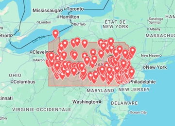
A Pennsylvania urbex map is useful because the state combines dense city edges, former industrial corridors, old rail towns, rural backroads and historic sites. But a map should never be treated as an automatic access pass. The real value is route planning: comparing areas, checking freshness, avoiding risky stops and keeping exact sensitive coordinates private.
This guide shows how to use map research for Pennsylvania abandoned places without publishing fragile locations or encouraging unsafe entry. If you need a practical starting point, open the Pennsylvania Urbex Map, compare the broader United States urbex map, or browse the full urbex map shop.
Why Pennsylvania is strong for map-based urbex research
Pennsylvania has several different exploration patterns in one state. Some searches focus on “abandoned places near me”, others on industrial ruins, rail heritage, schools, hospitals, churches, mills or small towns. A clean map workflow helps you sort those ideas by region and trip intent instead of chasing random pins across the state.
- Urban belts: useful for exterior photography routes, but they require careful checks for active use, neighbours and redevelopment.
- Industrial corridors: mills, warehouses and rail-linked areas can change status quickly, so current verification matters.
- Small towns: distances look short on a map, but access, parking, daylight and local context can vary a lot.
- Historic locations: some are better treated as legal heritage visits or exterior photo stops than as classic urbex targets.
- Rural roads: offline maps, fuel, weather and a backup route are more important than adding more pins.
Pennsylvania urbex route checklist
Use this before saving a place to your route
- Choose one region. Start with a city belt, valley, county group or road corridor instead of the whole state.
- Separate public and private options. Keep legal viewpoints, museums, heritage walks and exterior-only stops in your backup list.
- Check recent signals. Look for current photos, redevelopment news, business activity, fencing, signs and obvious security changes.
- Screen the safety risk. Remove places with unstable roofs, sealed interiors, active industrial land, live rail, flood exposure or forced-entry requirements.
- Plan the map layer. Save candidates in a private Google Maps list or KML file and avoid reposting exact coordinates publicly.
- Confirm the day plan. Review daylight, weather, parking, distance, phone coverage, fuel and emergency alternatives.
How to combine a paid map with Google Maps and KML
A paid Pennsylvania map can save research time, but it works best when you use it as one layer. Google Maps helps with driving and saved lists. Google Earth or KML helps with terrain, older imagery and visual context. Recent public sources help you understand whether a candidate still appears abandoned, renovated, demolished or active.
| Tool | Best use | What to avoid |
|---|---|---|
| Pennsylvania urbex map | Finding clusters and route ideas | Assuming every pin is visit-ready |
| Google Maps | Drive time, services, saved lists and road context | Following directions onto restricted property |
| Google Earth / KML | Terrain, old imagery and route structure | Trusting old satellite imagery as current proof |
| Recent photos | Checking if a place still looks relevant | Copying sensitive coordinates into public posts |
| Local context | Redevelopment, ownership clues and safer alternatives | Ignoring signs, fences, neighbours or active use |
If you work with exports, the Google Earth KML urbex map guide explains how to keep layers readable. For a broader state-by-state approach, use the abandoned places map USA guide.
Trip ideas by intent, not by exposed coordinates
The safest way to make a Pennsylvania route is to define the purpose first. That keeps the plan useful without turning the article or your notes into a public address list.
- Photography route: prioritize exterior textures, signs, brickwork, rail details and legal viewpoints.
- Industrial history route: research former mills, manufacturing corridors and rail-linked towns, then verify current status.
- Weekend scouting route: keep a small number of realistic stops and add backup legal alternatives nearby.
- Google Earth research session: compare clusters, measure distances and export only the short list that still looks practical.
- Local “near me” search: use search results as a first filter, then check legality, access, safety and freshness before any visit.
When the Pennsylvania Urbex Map is useful
The Pennsylvania Urbex Map is useful if you want to reduce research time and organize possible routes by state. It can help you see clusters, compare Pennsylvania with nearby states and decide whether a day trip, weekend route or wider USA map makes more sense.
- Use the map to structure research, not to publish exact sensitive locations.
- Verify every candidate with recent public information before planning travel.
- Respect signs, fences, neighbours, security, active businesses and private ownership.
- Prefer legal viewpoints and exterior photography when access is unclear.
- Keep safety checks, weather and backup routes in the same planning file as the map.
If you are comparing multiple states, use the Explore Urbex USA page or the United States urbex map. If you are still learning how to research responsibly, start with how to find abandoned places near you safely.
Safety and legal reminders
Urban exploration can involve unstable floors, broken glass, asbestos, mould, poor air quality, security patrols, heat or cold exposure and legal risk. A map can reduce research friction, but it never replaces permission, caution and common sense.
- Do not break locks, force doors, climb barriers or damage property.
- Avoid active industrial land, sealed buildings, live rail areas and unstable interiors.
- Do not explore alone when a place is remote or structurally uncertain.
- Carry water, light, sturdy footwear, a charged phone, offline maps and basic first aid.
- Leave immediately if a site appears active, restricted or unsafe.
FAQ: Pennsylvania urbex maps
Can I use Google Maps to find abandoned places in Pennsylvania?
Yes, but use Google Maps as one layer only. Combine saved places with Google Earth, recent public photos, local context and current access checks before planning any route.
Does a Pennsylvania urbex map make a place legal to enter?
No. A map cannot grant permission or guarantee safe access. Ownership, signage, security, redevelopment and structural condition can change at any time.
Should I share exact Pennsylvania abandoned place coordinates online?
It is usually better not to share exact coordinates for fragile, private or easily damaged places. Share planning methods, regions and safety checks instead.
What should I check before visiting a place from a map?
Check current status, visible restrictions, weather, daylight, structural risk, ownership clues, nearby activity and safe backup options.